
File:Egypt Topography.png

Size of this preview: 622 × 599 pixels. Other resolutions: 249 × 240 pixels | 498 × 480 pixels | 797 × 768 pixels | 1,063 × 1,024 pixels | 1,843 × 1,776 pixels.
Original file (1,843 × 1,776 pixels, file size: 2.9 MB, MIME type: image/png)
Summary
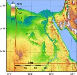
| Description | Topographic map of Egypt. Created with GMT from SRTM data. |
| Date | |
| Source | Own work |
| Author | Sadalmelik |
Licensing
| This work has been released into the public domain by its author, Sadalmelik. This applies worldwide. In some countries this may not be legally possible; if so: Sadalmelik grants anyone the right to use this work for any purpose, without any conditions, unless such conditions are required by law. |
File history
Click on a date/time to view the file as it appeared at that time.
| Date/Time | Thumbnail | Dimensions | User | Comment | |
|---|---|---|---|---|---|
| current | 00:47, 16 May 2025 | | 1,843 × 1,776 (2.9 MB) | wikimediacommons>JayCubby | Reverted to version as of 19:42, 29 June 2007 (UTC) why didja downscale it? |
File usage
The following pages on the English Wikipedia link to this file (pages on other projects are not listed):