
File:The Braaid - Isle of Man - kingsley - 21-APR-09.jpg
Size of this preview: 800 × 600 pixels. Other resolutions: 320 × 240 pixels | 640 × 480 pixels | 1,024 × 768 pixels | 1,280 × 960 pixels | 2,560 × 1,920 pixels.
Original file (2,560 × 1,920 pixels, file size: 1.42 MB, MIME type: image/jpeg)
Summary
| Description |
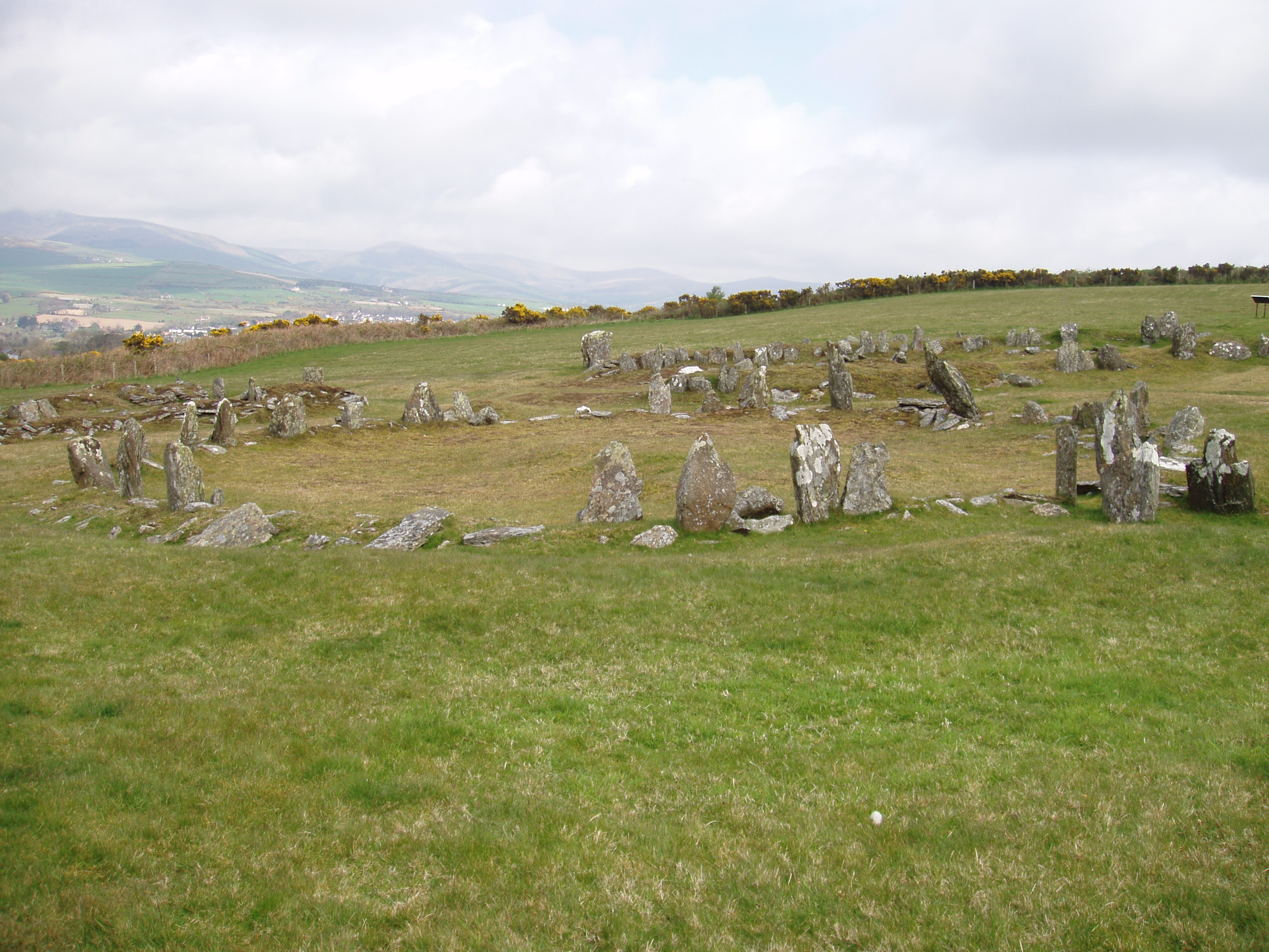
English: Part of the Manx Heritage Trail, The Braaid is the site of an ancient Celtic-Norse settlement. Remnants of a roundhouse (c. 650 AD) in the foreground and two longhouses (c. 950 AD) in the background can be seen here, situated on the rolling hills of Marown in central Isle of Man.
Gaelg: Myr ayrn jeh'n Raad Eiraght Vannin, ta'n Braaid ny ynnyd cummal shenn-aimsyragh Celtiagh-Lochlynagh. Ta fooilliagh thie cruinn (mysh 650 AD) 'sy toshiaght as fooilliagh daa hie-liauyr (mysh 950 AD) 'sy chooid sodjey magh ry-akin ayns shoh, soit er croink cassee Marooney ayns mean Ellan Vannin. |
| Date | |
| Source | Own work |
| Author | Gregory J Kingsley |
| OpenStreetMap | Way 1145362174 |
| Object location | | View this and other nearby images on: OpenStreetMap |
|---|
54°9′26.1″N 4°33′59.6″W / 54.15725°N 4.566556°W
| Camera location | | View this and other nearby images on: OpenStreetMap |
|---|
Licensing
I, the copyright holder of this work, hereby publish it under the following licenses:
This file is licensed under the Creative Commons Attribution-Share Alike 3.0 Unported license.
- You are free:
- to share – to copy, distribute and transmit the work
- to remix – to adapt the work
- Under the following conditions:
- attribution – You must give appropriate credit, provide a link to the license, and indicate if changes were made. You may do so in any reasonable manner, but not in any way that suggests the licensor endorses you or your use.
- share alike – If you remix, transform, or build upon the material, you must distribute your contributions under the same or compatible license as the original.

|
Permission is granted to copy, distribute and/or modify this document under the terms of the GNU Free Documentation License, Version 1.2 or any later version published by the Free Software Foundation; with no Invariant Sections, no Front-Cover Texts, and no Back-Cover Texts. A copy of the license is included in the section entitled GNU Free Documentation License. |
You may select the license of your choice.
File history
Click on a date/time to view the file as it appeared at that time.
| Date/Time | Thumbnail | Dimensions | User | Comment | |
|---|---|---|---|---|---|
| current | 08:36, 15 August 2009 | | 2,560 × 1,920 (1.42 MB) | wikimediacommons>Gregory J Kingsley | {{Information |Description={{en|1=Part of the Manx Heritage Trail, The Braaid is the site of an ancient Celtic-Norse era community. Remnants of two longhouses and a roundhouse can be seen here situated on the rolling hills of central Isle of Man near Mar |
File usage
The following pages on the English Wikipedia link to this file (pages on other projects are not listed):